Enterprise Bank – Pelham, NH

Commercial & Industrial
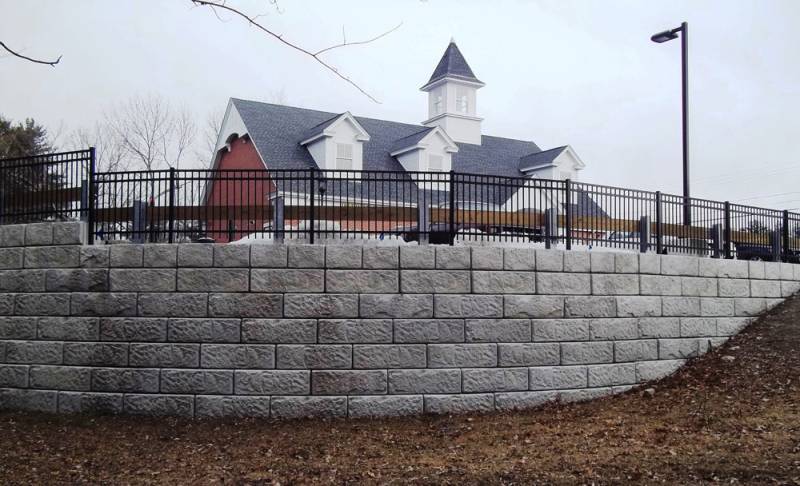
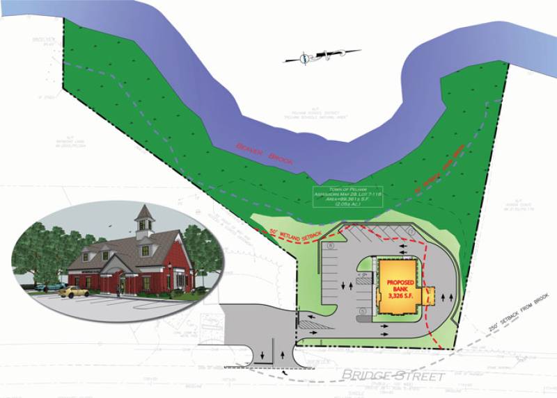
Winner of 2012 ACEC NH Outstanding Civil Engineering Achievement Award and 2012 Project of the Year Award from NH Planners Association located at 139 Bridge Street, the Enterprise Bank is a 3,235 square foot commercial development located within the heart of Pelham’s commercial district. Adhering to the old saying “don’t judge a book by its cover”, this seemingly typical commercial development it turns out, is rather atypical.
The subject parcel is located along the Beaver Brook within three overlapping resource areas; FEMA’s 100 year floodplain, NH Shoreland Protection limits and local Wetland Conservation District. The Town was favorable to the project but outlined concerns regarding wetlands, shoreland protection and flood prevention. At the time the project began, NH had just experienced two back to back 50 year storm events so flooding was fresh on the minds of the Town and its residents, in particular because of the major flooding of roadways and homes within the area of the Beaver Brook watershed. Although the regulations for floodplain impact were not applicable and the project did not fall under NHDES AoT rules or NHDES Wetland rules requiring compensatory mitigation, the Conservation Commission and concerned residents requested the Applicant to look into what could be done. Existing storm data from the USGS Water Information System website that monitors flood water levels in real-time were utilized to compare flood water levels to the known surveyed elevation of the floodplain at the site location. Local residents and Board members were able to visit the site during the seasonal spring flooding and see first hand the fluctuation of the floodplain. The Applicant supplied a 1:1 compensation of the floodplain that was displaced. In turn, the biggest critics of the project became the biggest supporters. The design itself included the bank, 20 parking spaces with two drive-thru lanes and a 24’ wide bypass lane to allow for fire truck circulation. The complete impact area for development encompassed approximately 43,000 square feet of an 89,360 square foot lot with Beaver Brook and the floodplain occupying all but 15,763 square feet (or 17.6%) of the lot. In order to fit the design on the lot, many issues had to be considered such as location of the septic system, well, stormwater infiltration chambers and flood storage all while maintaining required setbacks. The decision to raise the site to be completely out of the flood elevation in order to provide clearance for building finish floor and the stormwater system resulted in the design of a modular block retaining wall, which put the finish grade 8.5 feet above the flood elevation of 128.00 while at the same time utilizing concrete chambers to mitigate flood storage and help reduce the amount of fill required. Any portion of the parcel that remained undeveloped was deeded back to the Town as a conservation easement. A&M submitted and received all local and State permits including the Site Plan approval which was filed and subsequently approved in exactly fifty four days, a new record for commercial project permitting in Pelham. This achievement is credited to the coordinated efforts of the development team and Pelham Planning Director, Jeff Gowan who felt the bank would benefit the needs of the Town’s residents. Mr. Gown facilitated joint site walks and sessions with all three municipal Boards concurrently eliminating the delay of having to schedule multiple hearings. The willingness of the Town to accommodate the project along with timely responses from the developer and sub-consultants allowed this project to move forward rapidly and to a great end.
